Algeria


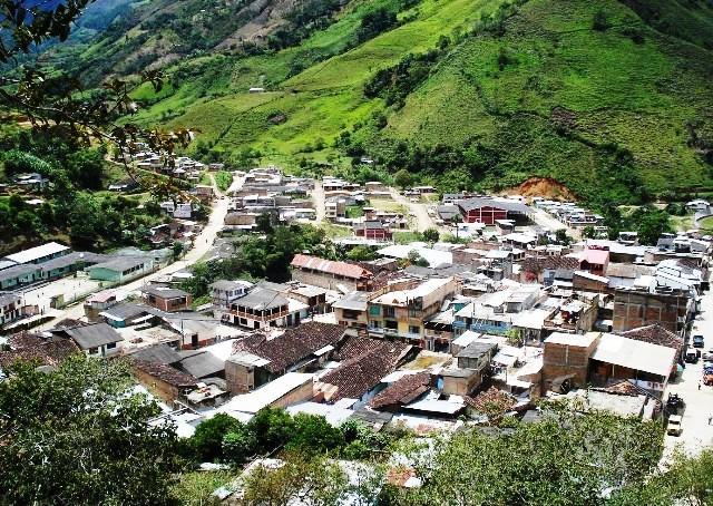
Cauca, Cauca, Colombia
Suggest Place to Visit
1138
Track to location with GPS |
 |
Founded date: November 08, 1967
Name of the founder (s): Juan Vargas, Liborio Sotelo, Demetrio Daza, Alejandrino Gaviria, Moisés Daza, Juan Mellizo, Félix Daza, Domingo Ceballos, Sixto Girón, Ernesto Hoyos, Licenia Rico, Francisca Muñoz, Emilia Daza, Prudencia Ruiz
At the time of the conquest, the territory that today corresponds to the municipality of Algeria was inhabited by the tribes of the Guapios, Telembias and Barbacoas Indians; these last few numerous and of wild customs. Five centuries later, when the first colonizers arrived between 1905 and 1918, a large part of the region produced the laurel wax with which candles and other derivatives were made for domestic use. This product was exploited by the inhabitants of the Algerian region until approximately 1965, becoming one of the main sources of economic income for the people who inhabited the contours at that time. Over the years, from the turn of the century, many immigrants began to arrive, coming from all latitudes of the country, especially from the Colombian southwest, and thus they were inhabiting the many hillsides and the few plains of the municipality, very possibly attracted by their lands fertility and in search of better living conditions. There were bundles of families from Valluna, Nariño, Tolima, Huilense and the inevitable paisas, either their own (Antioqueños) or those of the ´´viejo caldas´´, who by mixing their customs and idiosyncrasy came to make up the most interesting and varied demographic group that today inhabits the region. Creation as a municipality By ordinance number 02 November 08, 1967 of the honorable assembly of the department of Cauca, the most prominent leader being Mr. Aníbal De Jesús Arcila Castaño. Also working were Messrs. Carlos Guillermo Gamboa, Norbertino Adrada, Gerardo Bravo Audelo Erazo, Ulpiano Siluz, Heriberto Samboni, Jesús Giraldo, Álvaro García, Lila Nubia Solarte, Sonia Astaiza, Miriam Ruiz, among others.
Physical description:
The territory of the municipality of Algeria is made up of a huge knot of mountains, highlighting within these the part that corresponds to the orographic set of the Western mountain range, which has already begun the detachment of the great Andes mountain range, and the mountain range of El Pinche that covers another part of the Municipality, forming a quite rugged geomorphological zone. It is part of the Pacific Unit because it is located between the western slope of the Western Cordillera and the Pacific Ocean. As important heights in the Western Codillera there are the California hill, Alonso, El Tambor or Alejo, San Pedro, Lora, Plateado, Ramos and Guapi, as well as the Alto de Paramillo, which range between 2,400 and 3,500 meters high. above sea level. Special mention should be made of Cerro Plateado, which is the highest of the hills in the department of Cauca. In the El Pinche mountain range, the hill of the same name stands out, which is located at a height of 3,300 meters above sea level.
Limits of the municipality:
North: El Tambo East: Patía South: Balboa West: Guapi and Dpto.de Nariño
Total extension: 655.6 Km2
Urban area extension: 1.5 Km2
Rural area extension: 654.1 Km2
Altitude of the municipal seat (meters above sea level): 1250
Average temperature: 24º C
Reference distance: 87
Economy
The basis of the region's economy is agriculture, the main agricultural product is coffee and plans are being developed to replace crops with products such as: sugar cane, cocoa, among others.
Communication channels
Terrestrial:
The main access road to the Municipality is the route from El Estrecho Patía, passing through the Municipality of Balboa, ending its journey at the site called La Punta, Corregimiento El Plateado.
The territory of the municipality of Algeria is made up of a huge knot of mountains. It is part of the Pacific Unit because it is located between the western slope of the Western Cordillera and the Pacific Ocean
Algeria is a tourist site, its shape, structure and layout make this Municipality a little box of surprises. It is called the Palace of the Cordillera, in Algeria everything is close, Telecom, Acuavalle, the Bank, schools, colleges and a world of comforts that provide a better living. Its beautiful natural landscape made up of grasslands, coffee plantations, banana trees, mountains and mountains fill it with greens of all shades. The long walks “palo solo” from where you can see the great plan of Valle del Cauca; Meals and picnics at the Río las Vueltas, the festivities at the farms, the Sancocho de gallina, the Tolima suckling pig, the veal a la llanera, the brandy and the joy of its inhabitants make Algeria that center that is flooded with visitors during the good night, the return festivities, the Virgen del Carmen festivities and when tourists arrive.
Comments
We don´t have yet any comments about:
Algeria
Algeria
Be the first to leave a comment as it is very important to inform other people
Outros locais a visitar
Within a radius of 20 km from:Algeria
Unfortunately we do not have information on other places to visit in this area yet
Hotel reservation near Algeria within a radius of 20 km
No results
Why to book with ROTAS TURISTICAS
The best prices
Our partnerships with the world´s largest operators offer research on the best market prices.
More options
At Rotas Turisticos you can book the hotel, buy the air ticket, book the transfer from the airport to the hotel and vice versa, book the local excursions, rent the car, take travel insurance and consult the places to visit and where to go.
Holiday Tips & Destinations
Hundreds of holiday destinations with all the options that allow you to easily choose the destination that best suits your dream vacation.
ROTAS TURISTICAS
Links
Follow us on social networks


