Almaguer


Cauca, Cauca, Colombia
Suggest Place to Visit
888
Track to location with GPS |
 |
Foundation date: August 19, 1555
Name of the founder (s): Vasco de Guzmán and Alonso de Fuenmayor
Historical review:
On October 10, 1550, Briseño, alternate Governor of Popayán granted a license to a certain Guzmán disgust for a pacification and settlement entry. Whether Guzmán obeyed his reduced work of pacification is not known, the truth is that he did not abide by the terms of his cédula. Organized a modest expedition of 59 men, he left the pasture to the north, captured some Indians from Mancayapo and entered the province of Guachicone, whose conquest lacked authorization. There on a ledge in the mountains at an elevation of 2,300 meters, he founded what he called La Ciudad Del Cesar, then ALMAGUER
The infamous Álvaro de Oyón, who like Guzmán himself, just arrived from Peru, was appointed Mayor of the new foundation. The revolution in the region remained to be done, but Guzmán did not venture to conquer. The expedition members murmur, some deserted and finally the council sought the removal of
his inadequate leader. The replacement came when he ceased on July 14, 1551 in the person of ALONSO DE FUENMAYOR. As a commandment of the Governor, '' God for none (null) all
made by Don Vasco de Guzmán´´.
Fuenmayor founded the city for the second time, now with the name of Almaguer, to honor Briseño (a native of the Almaguer corral in La Mancha). According to this tradition, this ceremony took place on August 19, Saint Louis, the date is credible, but the name Saint. Luis, from Almaguer seems like an 18th century invention, perhaps to commemorate Don. Luis son of King Felipe V. (romuli, 1962). In conclusion, it was called the city of Cesar first and then Almaguer. "
Physical description:
The Municipality of Almaguer is located in the Department of Cuaca, to the south east of its capital Popayán and 172 km away from it.
It belongs to the so-called Colombian Massif, classified as the most important water factory in the country.
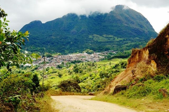
The town of Almaguer is located at the foot of the Belén - Panecillos hill and Santa Bárbara to the South as its tutelary hills, surrounded by the powerful massif of the Andes mountain range that to the NE of Almaguer forks to form the two gigantic branches of the Colombian Andes. From the knot in reference a multitude of mountainous buttresses and abutments emerge in all directions, giving rise to the small hydrographic basins of Rio Blanco, Marmato, Ruiz, Caquiona, Humus and San Jorge.
Limits of the municipality:
To the North: Municipality of La Vega - Cauca
To the south: Municipalities of Bolívar and San Sebastián Cauca
To the East: San Sebastián Cauca
To the West: Municipality of Sucre Cauca
Total extension: 320 Km2
Urban area extension: 0.33 Km2
Rural area extension: 319.67 Km2
Altitude of the municipal seat (meters above sea level): 2,312
Average temperature: 17º C
Reference distance: 172 km from Popayán
Ecology
The Main Ecological Structure of Almaguer is made up of three components whose connection consolidates a network throughout the entire territory, with clear integration between the urban and rural portions: The System of Protected Areas of the Main Ecological Structure, called “Los Bosques de Almaguer ”, The Special Management Areas of the San Jorge, Humus, Blanco, Caquiona, Ruiz and Marmato Rivers Rounds and the Integrated Park System.
Economy
Traditional agriculture, with a predominance of organic crops in small properties (chagra): coffee, sugar cane, banana, fruit trees. Bovine livestock. Smaller scale: Poppy, Coca. Rural - peasant economy.
Communication channels
Aerial:
Terrestrial:
The main road that allows Almaguer to communicate with the Department of Cauca and the Nation, is the one that from the city of Popayán passes through the Municipalities of Timbío, Rosas, La Sierra and La Vega; to its urban area.
The road system of the municipality of Almaguer is structured radially, with a center at the municipal seat: North Head: Municipality of La Vega, Pancitará. South Head: Municipality of Bolívar. West Head: Municipalities of Bolívar, Sucre and Patía. East Head: Municipalities of San Sebastián and Santa Rosa, passing through the towns of Santiago, El Rosal and Valencia. It is part of the so-called Colombian Massif road ring, which joins the municipalities of Rosas, La Sierra, La Vega, San Sebastián, Bolívar, Sucre and El Bordo (Patía), circulation that enables a market circuit that starts from the Pan-American highway and returns to it at the points of La Lupa (Municipality of Patía) and at the head of the Municipality of Rosas. The road on which we travel in the aforementioned circuit is departmental in nature, it has a width no greater than 8 m, allowing the circulation of two vehicles. Its finish is varied since pavement is found in the municipalities of El Patía, Bolívar and La Sierra. Material affirmed in the municipalities of Rosas, La Vega and San Sebastián.
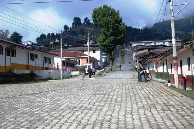
Almaguer is a historical and cultural heritage of the nation, in our municipality you can find different types of tourist attractions: our architecture is colonial in character, which makes our streets very pleasant territories. In turn, our municipality has a great variety of restaurants with typical food of the region, as well as very comfortable inns or hotels with rustic characteristics located in the central part near the church of colonial architecture. In the same way, most of our parks have pine pruned in the form of attractive figures.
Main festivities
Patronal Festival in Caquiona
Celebration of the Virgin of the Conception.
La Herradura Patronal Festival
The Corregimiento de La Herradura celebrates its patronal feast on February 11 of each year in honor of the Blessed Virgin of Lourdes.
Comments
We don´t have yet any comments about:
Almaguer
Almaguer
Be the first to leave a comment as it is very important to inform other people
Outros locais a visitar
Within a radius of 20 km from:Almaguer
Bolivar |
| 14,9 Km |
 |
Hotel reservation near Almaguer within a radius of 20 km
No results
Why to book with ROTAS TURISTICAS
The best prices
Our partnerships with the world´s largest operators offer research on the best market prices.
More options
At Rotas Turisticos you can book the hotel, buy the air ticket, book the transfer from the airport to the hotel and vice versa, book the local excursions, rent the car, take travel insurance and consult the places to visit and where to go.
Holiday Tips & Destinations
Hundreds of holiday destinations with all the options that allow you to easily choose the destination that best suits your dream vacation.
ROTAS TURISTICAS
Links
Follow us on social networks


