City Corinth


Cauca, Cauca, Colombia
Suggest Place to Visit
495
Track to location with GPS |
 |
Founded date: May 25, 1867
Name of the founder (s): Don Antonio Feijoo and his brother Juan Bautista Feijoo
In colonial times there was a vast territory to the north of the Department of Cauca, where the Municipality of Corinto is currently located, and which was ecclesiastically called El Curato de los Frisoles, of which the Hacienda called with the same name was its head. . In the second half of the 19th century, Mr. Juan Bautista Feijoo bought the aforementioned farm and in the company of his brother Antonio, they insisted on the creation of a town center, seeing their wishes fulfilled in the year 1867, when they founded the farmhouse that progressed rapidly, and is now known as the urban area of Corinth. On May 11, 1868, the category of Municipality of Corinto was granted.
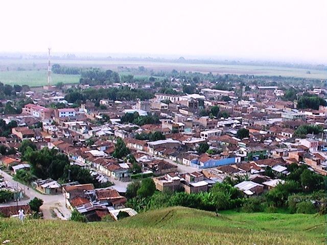
Corinto is a mountainous territory, located on the central mountain range 118 kilometers from its capital, Popayán, limits to the east with the department of Tolima, to the north with Miranda, to the south with Toribio and Caloto, to the west with Padilla, also Caucano municipalities. The Municipality is part of the ecological corridor of the Nevado del Huila National Park and the area of influence of the Colombian Massif, bathed by the Paila River. Its population lives basically from agriculture and livestock, the main crop is sugar cane and coffee follows.
Physical description:
Height above sea level: 1,090 m.
Average temperature: 22 ° C.
Average annual rainfall: 1,634 mm.
The police inspections of El Jagual, La Cominera, Los Andes, Media Naranja and Rionegro are part of the municipality.
The territory is mountainous and its relief corresponds to the western flank of the Central mountain range, with heights greater than 4,000 m above sea level, in the border area with the department of Tolima. It is irrigated by the Guengüe, Huasanó, Jagual, Negro and Paila rivers, in addition to numerous smaller streams. Their lands are distributed in the temperate, cold and bioclimatic páramo thermal floors.
Limits of the municipality:
North: Miranda
South: Toribio and Caloto
East: Department of Tolima
West: Padilla
Total extension: 302 Km
Urban area extension: 30.2 Km
Rural area extension: 271.8 Km
Altitude of the municipal seat (meters above sea level): 1050 and 4000
Average temperature: 24 and 13º C
Reference distance: 118 from Popayán
Ecology
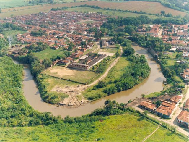
The location of the municipality of Corinto makes it part of the ecological corridor of the Nevado del Huila National Park and the area of influence of the Colombian massif; Therefore, it is necessary to implement proposals and projects aimed at conserving our environmental heritage. Hydrography The municipality of Corinto is located in the central mountain range, in the foothills of the Nevado del Huila National Natural Park; reason for which it has a well-represented hydrological system, it is part of the upper basin of the Cauca River, it provides a large number of water sources that discharge their waters to the Palo River sub-basin. The main river is called La Paila, which presents in the upper part, plant formations or life zones corresponding to fragile ecosystems that have already been intervened by the development of agricultural activities and the advance of illicit crops, affecting the native forest. The middle zone of the La Paila River is covered with crops and unmanaged natural grasslands, its main problem lies in deforestation and one of its causes is the consumption of firewood, which is estimated at 80% in rural areas. The flat area is entirely covered by sugar cane, the river waters present limited survival conditions, due to the wastewater and residual waters of the mills.
Economy
The economic activity of the rural area is based on agriculture and livestock, there are incipient agricultural farms, in a traditional way. The main crop is sugar cane, occupying 23.4% of the total area, coffee cultivation occupies 4.4% of the total area. In large private properties such as Antioqueñita, El Edén, Potreros Grandes, Los Olivares, Haciendas Ukrania, García down, Villa Juliana, Miraflores, Quebradaseca, García Arriba, El Tablon, El Guayabo, La María, there are large crops of cane, yucca , livestock and livestock exploitation and sugar mills. On the part of the community, there have been attempts to organize agricultural projects but their results have not been satisfactory, due to lack of training and permanent technical assistance. In the mining sector there is a large amount of river drag materials, for their correct exploitation municipal regulations are required in this regard and permits from the CRC and Minercol, there is also an artisanal exploitation of marbles by the Calizas y Mármoles Ltda Company There are organizations or institutions created to develop specific agricultural projects or provide support to specific sectors, they are: Peasants without Land, Peasant Reserve Zones, Indigenous Council, Asmudescor, National Federation of Coffee Growers; On the part of the municipal entity is the Municipal Agricultural Technical Assistance Unit (Umata). The urban area has a variety of commercial establishments, predominating the places where alcoholic beverages and food are sold, with respect to the commerce of other articles is incipient, small, familiar commercial establishments predominate. In the urban sector there is a general trend towards the breeding and sale of minor species such as chickens and pigs, seasonally, to solve immediate economic problems. The main source of employment is generated in his order by the sugar mills, followed by formal trade from which some 450 families generate their livelihood.
Microenterprises and Incorporated Family Businesses
Paletata: Products
La Japonesa: White Manjar Factory
San Diego: Associative Labor Company
The Spring: Espiga de la Caña
Jacobito Sweets: Brillyt Recycling
Distribuidora el Campesino: Warehouse and brick factory
La Nubia: Chanclería
La 10: Nursery El Rosal
Corinthian quail
Crea Sport: Manufacture of Sportswear
Cleaning implements: Broom Factory, mops, dust collectors
Association of microentrepreneurs
Communication channels
Terrestrial:
The municipality's road network consists of 188 kilometers of highways, of which 27.2 are paved and 160.8 km are unpaved. We have 7 road axes, which are in fair or bad condition, require maintenance for the proper functioning of means of transport such as goats, camper vans and other vehicles. It is necessary to improve the public works teams, for now requesting the support of the sugar mills to begin work on the adaptation and maintenance of the municipality's tertiary roads, creating commitments with the communities, so that the work has good results.
Regional roads
Via Distance in Kilometers (Km.) From Corinto to:
Popayan 118
Cali 53
Santander De Quilichao 39
Puerto Tejada 25
Miranda 10
Municipal roads
Via Distance in Kilometers (Km.) From Corinto to:
El Palmar 22.1 axis
Chicharronal 6 Axis
Axis La Esmeralda 10.7
El Boqueron 16 axis
La Cominera 12.3 axis
Axis San Luis Arriba 14.5
The Barranco 8 axis
Others
Rio Negro Cruise Line - The Alps 8
The urban area road system is made up of a 23.1 km road network, of which 18 km are paved. The unpaved roads are located in the peripheral neighborhoods of the municipal seat. Barrios Pedregal, Esmeralda, La Playa, La Colombiana, 20 de Agosto and the Villa del Rosario Urbanization.
Places to visit:
Parks
Recreational Park ´´El Saman´´
This site has a swimming pool for children and one for adults, it is open to the public from Monday to Sunday, from 8:00 to 6:00 pm, entrance: 500 children and 1000 adults. It is located next to the El Jardín school.
Recreational park ´´La Finca´´
This is a site that has a swimming pool for adults, one for children and a large one for adults, all with natural water; It also has 5 soccer fields, 10 wood stoves, parking, bar, room for social events, dance floor. General admission 1000. Due to its location, it is a very popular place for Corinteños.
Rio La Paila
In hot season so that more than some delicious puddles, in the La Paila river; In addition, you can prepare a magnificent lunch on the banks of the river.
Recreation
Sport Fishing El Edén
El Edén has four sport fishing lakes where you will find a variety of fish such as: carp, tilapia and cachama. It is located on the road from Corinto that leads to the Santa Elena path. This place is very visited for the Easter season.
Natural reserves
La Cominera Waterfall
This is one of the waterfalls that the Municipality of Corinto has, it is located in the town of Jagual, in the path of La Cominera.
Comments
We don´t have yet any comments about:
City Corinth
City Corinth
Be the first to leave a comment as it is very important to inform other people
Outros locais a visitar
Within a radius of 20 km from:City Corinth
Puerto Tejada |
| 18,4 Km |
 |
Hotel reservation near City Corinth within a radius of 20 km
No results
Why to book with ROTAS TURISTICAS
The best prices
Our partnerships with the world´s largest operators offer research on the best market prices.
More options
At Rotas Turisticos you can book the hotel, buy the air ticket, book the transfer from the airport to the hotel and vice versa, book the local excursions, rent the car, take travel insurance and consult the places to visit and where to go.
Holiday Tips & Destinations
Hundreds of holiday destinations with all the options that allow you to easily choose the destination that best suits your dream vacation.
ROTAS TURISTICAS
Links
Follow us on social networks


