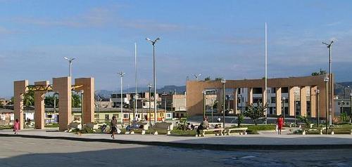
City of Bagua Grande


Bagua Grande, Amazonas, Peru
Suggest Place to Visit
1296
Track to location with GPS |
 |
In the Secondary or Mesozoic Era, the sauropod Titanosaurus and the theropod Carnotaurus Sastrei lived in Bagua. In those days, Bagua was a coastal region (see picture 1), so on its soil we currently find both specimens of marine origin (clams, ammonites, and other mollusks) (see photo 2), and terrestrial specimens (herbivorous and carnivorous dinosaurs) (see photo 3),
The Baguatherium jaureguii lived 31 million years ago in the valley of what is now lower Utcubamba, it was a mammal 3 meters long and 2.5 tons in weight. They were characterized by having two pairs of upper tusks and a lower pair, they had elephantine legs, a massive body and a small trunk, they had the hydrid characteristics of a rhinoceros and a sachavaca; paleontologists point out that it fed on plants that grew on the shores of a sea located in what is now the Amazon. [1] Direct access to Bagua Paleontology.
Around 1300 to 200 BC. C. (formative period) the great Bagua Culture flourished in the areas, which is one of the oldest in northeastern Peru. According to archaeologist Ruth Shady, who discovered this culture, the Bagua were communities experienced in pottery, agriculture, hunting and fishing; When they were consolidated, they strengthened ties with peoples further north and central Peru.
In the 15th and 16th centuries the entire valley of the lower Utcubamba was inhabited by the Bagua nation. According to Diego Palomino's document called the Relationship of the Provinces in Chuquimayo (Chinchipe), the Bagua were expert swimmers, they cultivated the land, they had their homes on the bank of the Bagua River (today the Utcubamba River). Palomino also informs us that the Bagua had their own language, which, like many other aboriginal languages, has become completely extinct (see photo 4).
Starting in the 16th century, the Spanish made their first forays into what is today both the Bagua and Utcubamba provinces. Captain Juan Porcel de Padilla was the first Spaniard to reach these latitudes, founding the disappeared town of Jerez de la Frontera. In 1535 Captain Alonso de Alvarado came in pursuit of some indigenous people and reached the height of Tomependa (Pongo de Rentema). In the year 1549 Diego Palomino traveled through the Utcubamba valley, then he went both to what is currently Jaén and San Ignacio to found the primitive Jaén on the left bank of the chinchipe.
In May 1902, Manuel Antonio Mesones Muro, the ethnologist Enrique Bruning and the engineer Habich (delegate of the waterways board) arrived in Bagua with the purpose of demonstrating that Etén and El Marañón could be united in just four days. On the banks of the Utcubamba river they began to prepare a raft of fourteen poles, of which seven were willows, to travel to Puerto Melendez, but because they had not achieved anything better, Mesones reduced the crew and left with only three bogas and a private servant.
Bagua Grande, a town also known by the name of Utcubamba, is the capital of the Peruvian district of Bagua Grande, in the Amazon region, which is in the north of Peru.
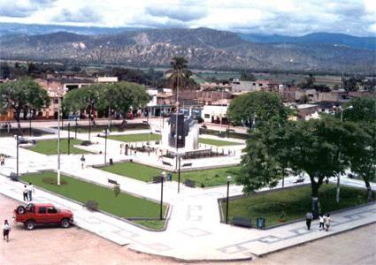
Bagua Grande is a beautiful and warm place, with very charitable, friendly and caring people. If I told you about its environment ... its nature is something incomparable, it is a true wonder to get to the places that were discovered. Well, some made by our ancestors and others just discovered.
The city of Bagua, capital of the province of Bagua, is located on a natural platform raised on the right bank of the Utcubamba river; at 400 meters above sea level on the cliffs of the Utcubamba river, in the Héroes del Cenepa square at 420 meters above sea level, on elevated headlands such as the Buen Pastor cemetery, 500 meters above sea level and 575 meters above sea level on Cerro dos de Mayo.
Pongo de Rentema: (La Peca-Bagua) is the entrance of the Marañón River in the central mountain range. It is located only 14 km from the city of Bagua and 400 meters above sea level
Numparket-Nueva Esperanza Waterfall: (Aramango-Bagua) has a fall of 90 m high, its waters will constitute the Aramango ravine.
El Tigre Waterfall: (Copallín-Bagua) located in the El Tigre sector (Cerro el Mono), You have to take mobility from Copallìn to Cambiopitec and then walk 3 hours to get to El Tigre, there is a bridle path and the waters they are going to thicken the Copallín creek.
San José Alto Waterfall: (Copallín-Bagua) is located in the San José del Alto hamlet and has three waterfalls that are located in the upper course of the La Flora stream, 2.5 ha on foot from Copallín and 40 minutes by mobility to San José del Alto, from where you walk for an average hour, following the left bank of the ravine.
Laguna El Porvenir: (Aramango-Bagua) its area is 1.5 km. The depth of 80 m in the deepest part. It is only two hours from Bagua, by rural truck. It is favorable for swimming and boating.
Archaeological site of Anguyo Alto or Llactán: (La Peca-Bagua) is located two hours from the town of Arrayán, It is a series of buildings on the skirt of the central mountain range of the Andes, the structures are semi-circular. and possibly it served as a surveillance place, since from there you can see the entire valley of the lower Utcubamba, Marañón and Chinchipe.
Caverns of Cambiopitec: (Copallín-Bagua) are two caverns that in the formative period had human occupation, it is located in the hamlet of Cambiopitec; To get there you have to bustle for two and a half hours on foot or thirty minutes by car from the town of Copallín; stairways have been built for access. Anytime in the year is a good time for visits.
El Eden speleological complex: (Copallín-Bagua) is located between the hamlets of Pan de Azúcar and Soles, at a distance of two hours on foot from Copallín. There is a conglomeration of caves, they are 5 of both small and medium heights and have an approximate depth of 400 m.
Morochal Caverns: (Copallín-Bagua) located in Morochal, 2 and a half hours walk from Copallín. There are 5 deep and mysterious caves eroded by groundwater.
Devil's Mouth Cavern: (Copallín-Bagua) located in the Monte de los Olivos farmhouse, a 3-hour walk from Copallín to the Buenos Aires farmhouse. From there you have to walk about 10 minutes along a bridle path in a mountainous area. Inside we can see large blocks of stone with suggestive shapes, it has a depth of 500 m, the entrance is very rough.
Churuyacu Cavern: (La Peca-Bagua) this cave is located one hour from the La Peca district, between winters and coffee crops. Its entrance is rugged, its interior with large and narrow passages, a large number of stalactites and stalacmites.
El Arenal Canyon: (La Peca-Bagua) beautiful natural cut of the mountain range made by the La Peca creek.
Native communities: (Bagua and Condorcanqui) are ethnic groups that belong to the group of Jíbaros. They inhabit the jungle districts of Bagua, Aramango and Imaza. They have their own dialect and unique craftsmanship. Representatives of this human group are the Aguarunas and Huambisas.
Local fauna: (Copallín-Bagua) the national bird of Peru (the cock of the rocks) inhabits the place, in the same way as the yellow-tailed woolly monkey (the only endemic monkey in Peru and in danger of extinction).
Quinine tree: (La Peca) grows the greatest plant symbol of the country, the cinchona tree or also known by the living of the place as cascarilla.
Comments
We don´t have yet any comments about:
City of Bagua Grande
City of Bagua Grande
Be the first to leave a comment as it is very important to inform other people
Outros locais a visitar
Within a radius of 20 km from:City of Bagua Grande
Bagua City |
| 14,9 Km |
 |
Hotel reservation near City of Bagua Grande within a radius of 20 km

Why to book with ROTAS TURISTICAS
The best prices
Our partnerships with the world´s largest operators offer research on the best market prices.
More options
At Rotas Turisticos you can book the hotel, buy the air ticket, book the transfer from the airport to the hotel and vice versa, book the local excursions, rent the car, take travel insurance and consult the places to visit and where to go.
Holiday Tips & Destinations
Hundreds of holiday destinations with all the options that allow you to easily choose the destination that best suits your dream vacation.
ROTAS TURISTICAS
Links
Follow us on social networks


