City of Mitú


Mitu, Vaupes, Colombia
Suggest Place to Visit
1323
Track to location with GPS |
 |
Historically, the Amazon region and the founding of the municipality of Mitú, have been framed in deep rivalries and social conflicts. The indigenous people came to these jungles for more than twelve thousand years. The researchers say that during those times the sea level rose to such a point that reservoirs, streams and wetlands of the lower Amazon were being completely covered with water; therefore the population traveled upstream following the course of the rivers and streams through the immensity of the jungle, being divided into groups. By distancing themselves from each other, they began to differentiate in their languages and histories, in their forms of socio-political organization: their music and dance, their knowledge of plants and animals, of the lands and waters, the management of diseases and even the ways of teach and learn. With time the population was increasing and expanding and the territories for hunting and fishing were less and less; This was the reason for the people to start fighting intensely. While some sought to possess a territory, others tried to defend it. Despite the differences between the tribes, especially between the Makúes and Tucanos, they sought rapprochement through exchanges and alliances that would lead them to live in harmony and congruence with the delicate ecological balance of the jungle. The presence of the whites as the people of the interior are called “can be explained by thinking of the religious and the laity. The missionaries came to this region since 1550 with the aim of Christianizing the indigenous people and turning this territory into the land of God. They built villages and ways of bringing the indigenous people together to achieve their evangelizing goals ”. The laity or first conquerors such as Mr. Hernán Jiménez de Quezada in the year 1538 and a German named Phillip Von Hutten in the year 1541, not content with all the riches stolen in the highlands of the center of the country, continued to search the plains and in the jungles. From 1890 to 1920, English, Portuguese and Dutch companies exploited black rubber, balata rubber and other products typical of the jungle. In 1903 there is a great rivalry between Brazilian and Colombian rubber tappers, due to the monopolization of labor, mainly in the basins and margins of the Negro and Apaporis rivers. Around 1911 there was a wave of settlers who came from Huila, almost all ex-combatants of the Thousand Day War attracted by the rubber boom. The activity of the Colombian rubber tappers was mainly centered in the upper and lower Vaupés, the Papurí River and the Tiquié area; areas characterized by the hunting of indigenous people through indebtedness for the purchase of items that their employer sold them, a situation that generated a form of slavery concealed by employers. The Tucanos and Carrijonas ethnic groups were settled in this area. In October 1936 Miguel Cuervo Araoz arrived in Mitú when it was only a hamlet giving it the name of Mitú, which means Paujil, a name that corresponds to a wild bird from eastern Colombia in the Yeral language, a meeting point between the different indigenous communities, of rubber exploitation , of skins and missionary center. Its main activity was the commercial exchange of rubber for food, clothing, fuel, among others. In the 1940s, the RUBER DEVELOPMEN CORPORATION acquired the monopoly of the exploitation of rubber, presenting the rubber boom as a result of the demand of the Second World War. Other companies such as La Casa de Rosas del Brasil and Casa Arana del Perú, who gave the indigenous inhuman treatment, mistreatment and abuse, going so far as to mark their skin with hot irons. The rubber boom ended because of the competition generated by the appearance of Asian rubber, synthetic rubber and the deforestation of the jungle. In the sixties there was a fur bonanza that ended with the denunciations for the extermination of species such as the tigrillo, the tiger, the lobón (water dog), the otter among others, giving strong damage to the fauna and the balance of the Amazon rainforest ecosystem. In the years 1979_1983 there was the coca bonanza, “years in which public positions were not profitable. During these years, everyone had money, then there was great misery, both material, spiritual and moral, because coca removed and destroyed the most intimate structures of the indigenous culture; in addition to corruption and the crisis of values of the inhabitants ”Later the official positions were coveted again, the contracts and supplies with the official entities and the money of the transfers for the indigenous communities that to this day sustain the economy of the municipality . The municipality of Mitú, capital of the then Vaupés Special Police Station, was created by National Decree No. 1666 of August 6, 1974. Its first mayor was Mr. Jorge Enrique Jiménez, appointed by decree No. 090 of April 14, 1975. The Municipal Council was installed for the first time on November 5, 1976. With regard to sanitation problems, historically each boom period has been of high production of solid waste since food, drinks, appliances have been imported from Europe and Brazil in time of the rubber plant and of the city of Bogota and Villavicencio in other times, even with the coca boom. These imports generated waste glass, cardboard, plastic, cans, among others. According to Mr. Julián Perilla, community leader interviewed, the farm where the municipal dump is currently located is owned by the Perilla family; his grandfather, Don Domingo Perilla, was a settler who lived there for approximately 70 years with his descendants. Approximately 25 years ago its owner loaned one hectare to the Municipality to use as a dump.
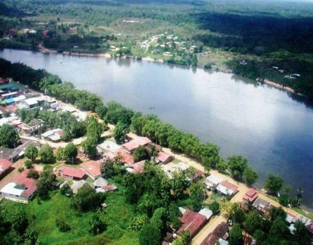
Mitú is the capital of the department of Vaupés, which is in the southeastern part of Colombia with the border of Brazil, the Municipality is located predominantly on the right bank of the Vaupés river. With about 16,422 km according to the Dane census and with an approximate population of 16,580 inhabitants where the indigenous race predominates with a variety of 27 different ethnic groups. Mitú is characterized by being a transition sector between the dry plains of the Orinoquía and the Amazon rainforest. Its temperatures range between 25 and 30 ° C with an approximate distance of 660 square kilometers (by air) to the south east of Bogotá, we are an incredible destination to start an adventure through the various attractions of the region such as caves, petroglyphs, beaches , islands, hills, indigenous communities and different natural spas of surprising beauty. The city is small but it has all the potential resources to start ecotourism or adventure tourism.
Geographically, the Municipality of Mitú is located in the Department of Vaupés which is in the south-eastern part of Colombia with the border of Brazil, it is the capital of the Department, the Municipality is located predominantly on the right bank of the Vaupés River.
Location
The municipality of Mitú is located between 000 14 "and 10 48" ° north latitude and between 690 50 'and 700 30' long west of the Greenwich meridian.
Economy
Ground uses
More than 98% of the municipality's land is covered with tropical forests, which are part of the Amazon Forest Reserve, through Law 2 of 1959, therefore its uses are conditioned to protection and production-protection uses. This area is also an Indigenous Reserve through INCORA Agreement 086 of 1982, determining that it is a collective territory of the indigenous people that is compatible with the Forest Reserve. There is 1.5% of the land use of the Municipality, known as the settlement area, framed in one km on the side and side of the Mitú-Monforth highway, which has a projected extension of approximately 105 km. Currently the road reaches Km 57 where agricultural activities are carried out by settlers and indigenous people.
Agricultural use
The agricultural use is determined by an itinerant agriculture of the polyculture system called chagras; which in most cases is the responsibility of the woman. It is also very common to produce surplus crops to be marketed in the city of Mitú. The chagra is an area of primary, secondary or stubble forest that the indigenous people cut down and burn in order to establish various associated and intercropped crops; After two or three years, when the soil loses its fertility, it is abandoned, leaving it planted with fruit trees and palms that will be used as a future collection site known as "pepeo". The approximate area of a farm is one to two hectares. This activity is established mainly on the Mitú-Monforth road and in areas surrounding the indigenous communities. Where the main crops of bread to catch are: yucca, corn, coca, banana, sweet potato and yam. The fruits that are cultivated in the region are: lulo, borojo, araza, papaya, zapayo, watermelon, sapote and cocoa. There are also other types of fruit trees known as Amazon: umari, ucuqui, caimo, marañon, copoazu, caimarona grape, ibapichuna, others: Amazon palms: wasahi, pataba, pupuña, miriti, inaya, corombolo, others.
Cattle raising
Livestock in the municipality was promoted in the second half of the 20th century, by religious missionaries in the indigenous communities and by the state on the Mitú - Monforth highway; In general, it is extensive, and at this time it is an incipient activity, with a low level of technological exploitation. In general, the sustainable livestock activity in the municipality is unknown, partly because adequate management and soil conservation practices have not been developed; as can be the models of intensive agrosilvopastoral production that allow to achieve continuous productions without degrading the environment in an irreversible way. Recreational and landscape use. In the municipality there are natural areas of rich landscapes whose function is rest or recreation and sports activities such as: Caño Cucura, Raudal del Yuruparí, Cachivera de Santa Cruz and Cuevas de Urania. These areas do not have infrastructure or adequate management by tourists who visit them, generating garbage problems and deterioration of water quality, among others.
The beauty of its natural landscapes and the wealth of fauna and flora offer a certain tourist attraction, which includes unique species of fauna and flora. The main crops are cassava or tapioca, corn, plantain, yams, and wild fruits. Mining resources such as gold and ilmenite are exploited.
Natural parks
There are no natural parks, it must be taken into account that the municipality as a whole is part of the Amazon forest reserve declared by Law 2 of 1959 and to date the area corresponding to the urban sector of Mitú has not been subtracted. Because practically all the territory is jungle, there are no wooded remnants, much less planted forests. The following hills in the municipality stand out, although their heights are between 100 and 300 meters above sea level, they are scattered hills, with rounded ends and in most cases without vegetation. Composed of precambrian crystalline rocks, with granite textures. These are the outstanding ones: Guacamayas, Pringahermosa, Pirapuku, Santa Lucia, Peña de Guamoya, Avina, Pedo de la Guacamaya, Tui, Utura, Cacuri, Pecu, Banco de Tigre, Banco de Morroco and Trueno. Unfortunately public order does not allow access to the Guacamayas hill, the closest to the municipal headquarter, so this cannot be considered as a viewpoint. CULTURAL LANDSCAPE The elements of the cultural landscape present in the municipality are the most relevant elements of the natural landscape and that coincide with the sites of great significance for the indigenous cultures present in the territory and stand out, among other cultural-natural landmarks, the cachiveras, the rapids , miritizales, caves, salty, the hills. FLORA AND FAUNA The department of Vaupés is characterized by being one of the departments that has great biodiversity, both in flora and in wild and hydro biological fauna. The forests of the Vaupés are characterized by the fact that a competitive strategy of many species (per unit area) is developed in their area, whose large biomass makes an almost exclusive storage of the mineral elements that provide nutrients to the vegetation cover by way of recycling. The vegetation of the department is conditioned to the parental materials and the texture of the soils and conditions in turn of their drainage; resulting in stunted herbaceous, shrubby, palm, dense forest, plain vegetation or surface soil vegetation (where there are rocky outcrops).
Mitú has cultural richness, it is suitable for cultural tourism. The indigenous cultures present in the territory stand out among other cultural-natural landmarks. You can see streams, cachiveras, miritizales, caves, salt flats, hills, etc.
Flora and fauna
It is characterized by biodiversity, both flora and fauna. Forests are characterized by the fact that several species develop in their area.
The flora resource is used by indigenous communities and the local population. It is very useful for different purposes: as medicine, wood supply, cooking, ornamental and industrial for the manufacture of oils, resins, fibers, dyes, etc.
Mitú is also rich in fauna, 586 species of wild fauna and 96 species of fish have been found, of which a large number are used by indigenous communities: as food, for ritual acts, in indigenous culture, as medicine and in other cases in the manufacture of musical instruments or the decoration of traditional indigenous cultural events. Among the most important species are tapirs, cerrillos, deer, tintins, churucos, paujiles, parakeets, guaras, etc.
Comments
We don´t have yet any comments about:
City of Mitú
City of Mitú
Be the first to leave a comment as it is very important to inform other people
Outros locais a visitar
Within a radius of 20 km from:City of Mitú
Unfortunately we do not have information on other places to visit in this area yet
Hotel reservation near City of Mitú within a radius of 20 km
No results
Why to book with ROTAS TURISTICAS
The best prices
Our partnerships with the world´s largest operators offer research on the best market prices.
More options
At Rotas Turisticos you can book the hotel, buy the air ticket, book the transfer from the airport to the hotel and vice versa, book the local excursions, rent the car, take travel insurance and consult the places to visit and where to go.
Holiday Tips & Destinations
Hundreds of holiday destinations with all the options that allow you to easily choose the destination that best suits your dream vacation.
ROTAS TURISTICAS
Links
Follow us on social networks


