Filobobos River


Martínez de La Torre, Veracruz, Mexico
Suggest Place to Visit
2143
Track to location with GPS |
 |
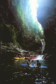
The route along the Filobobos River is approximately 25 km, starting from the Puente Filo community to the La Palmilla bridge.
During the journey you will be able to admire a beautiful tropical rainforest and local and migratory birds.
For the navigation of this river, experts distinguish three segments: the Upper, the Intermediate and the Lower Filobobos.
The first runs from the town of Zapotitlán (the river is near it) to Puente Filo and has some class IV and V rapids, navigable only by connoisseurs of this sport; the second goes from Puente Filo to the El Encanto waterfall, its rapids are type II and III; Finally, the Bajo Filo runs from the same waterfall to the La Palmilla suspension bridge, in its channel you will find level II and III rapids.
These degrees of complexity occur during the season when the river has a high level, which runs from September to November; However, the crossing can be done throughout the year, only that the rapids decrease in intensity.
During the descent of the river you will be able to make various stops to observe the archeology found in the area, such as the El Cuajilote ceremonial center and the Vega de la Peña Totonac City, as well as the La Tomata and El Encanto waterfalls, both natural wonders.
Location:
The Filobobos River is located in the Municipality of Tlapacoyan, Veracruz, 9 km from the community of the same name.
The part of the river known as El Alto Filo begins near the community of Zapotitlán.
How to get:
Departing from the Federal District, take the México-Puebla Highway to San Martín Texmelucan.
Passing the location of the old booth, take the exit to the right to pass over the bridge, following this bypass until the junction with the road that goes to Tlaxcala.
When you get to the town of El Carmen (junction of the Amozoc-Oriental Highway), turn left to connect 10 km with the highway to Teziutlán.
Continue towards Nautla (32 km) until you reach Tlapacoyan.
To get to Zapotitlán you have to travel along a dirt road of 22 km from the town of Altotonga; from there the descent on foot to the river begins and with the help of some donkeys to carry the equipment.
The ideal is to go in a group, since the descent of the river is a wonderful experience to share with friends.
The high season with the rains offers the best thrills, but not necessarily the best weather.
Do not forget to bring repellent, because mosquitoes are a nightmare.
If you contract with a company, take your precautions because there are many pirates that operate in these rivers; most do not have the proper equipment or personnel to make a safe descent; Although they charge much cheaper the risk can be very high.
Comments
We don´t have yet any comments about:
Filobobos River
Filobobos River
Be the first to leave a comment as it is very important to inform other people
Outros locais a visitar
Within a radius of 20 km from:Filobobos River
Unfortunately we do not have information on other places to visit in this area yet
Hotel reservation near Filobobos River within a radius of 20 km

Why to book with ROTAS TURISTICAS
The best prices
Our partnerships with the world´s largest operators offer research on the best market prices.
More options
At Rotas Turisticos you can book the hotel, buy the air ticket, book the transfer from the airport to the hotel and vice versa, book the local excursions, rent the car, take travel insurance and consult the places to visit and where to go.
Holiday Tips & Destinations
Hundreds of holiday destinations with all the options that allow you to easily choose the destination that best suits your dream vacation.
ROTAS TURISTICAS
Links
Follow us on social networks


