Puerto Carreño


Puerto Carreño, Vichada, Colombia
Suggest Place to Visit
722
Track to location with GPS |
 |
In 1913 the Vichada commission was created. By the time the aforementioned commission was created, an ideal place was sought for its capital and finally it was established at the confluence of the Meta and Orinoco rivers, in a place called the Picacho.
If you like the name of the capital of Vichada, Puerto Carreño, you can also find Pedro María Carreño, Minister of Government at that time. The municipality was created by decree 1594 of August 1974. On July 5, 1991 Vichada was elevated to the category of Department and Puerto Carreño was ratified as its capital.
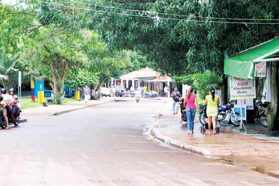
Puerto Carreño is the capital of the Colombian department of Vichada. Its population is 10,034 inhabitants, its extension is 12,409 km. And it is near the border with Venezuela, from where it is north of the Meta River with Puerto Páez.
It is a small settlement, founded in 1922, at the confluence of the Orinoco and Meta rivers. From its river port the commercial activities and the transport of merchandise of the department with the capital of Colombia are carried out.
The municipal term has an extension of 12,409 km. It will be chaired by a notarial circle that will include the municipality of Puerto Carreño and the departmental correctional facilities of Santa Rita, San José de Ocune and Cumaribo, with a notary; It was headed by a main registration circle with jurisdiction over the entire department. It belongs to the judicial party of Villavicencio and corresponds to the electoral district of Vichada.
The most important economic activities in the region are livestock, fishing, agriculture and mining.
The main agricultural products are: savanna rice, cotton, cassava and banana. Ornamental fishing and livestock stand out. Gold and silver mines are explored in a rudimentary way.
The town offers places of tourist interest such as the coastal town of Casuarito, from which articles and manufactures in clothing and textiles and typical foods are produced, having been registered in commercial establishments.
The municipality is supplied with basic and basic necessities, from the interior of the country, and sometimes from Puerto Páez, a city in the Venezuelan state of Apure, on the border with Colombia.
Its climate is of a warm thermal floor, the temperature of the regions is approximately 28 ºC, with abundant rains between the months of April to October. The trade winds blow strongly from December to April.
The predominant vegetation of the regions is tropical grassland mixed with gallery forest.
The municipal territory corresponds to the physiographic profile of the eastern banks formed by flat and undulating heights and flat heights to streams with local outcrops of the Guyanés shield, highlighting the orographic formations such as the Casuarito and the Hormiga and Guaripa hills.
In the municipality there are 5 indigenous guards called Cañón de Bachaco, Cañón de Guaripa, Cañón de Hormiga, Mesetas, Dagua and Guacamayas - Most of the Guaibo ethnic group and linguistic family in 1995 had 2,176 urban buildings and 339 rural properties.
The best place for ecological tourism is:
´´El Tuparro´´ Natural Park
It was created in 1970 and declared a National Monument and also a UNESCO Biosphere Reserve in 1982.
This Natural Reserve is located in the Eastern Plains, in the department of Vichada, in the jurisdiction of the municipality of Puerto Carreño.
It has an area of 548,000 hectares, the Park is delimited by the Orinoco River which serves as a boundary to the east, on the border with Venezuela, and to the west around the confluence of La Hormiga. To the north, the limit follows the direction of the Tomo river. It is located at a height of 100 to 330 meters above sea level, it has a very warm climate of approximately 27 degrees Celsius that draws the attention of all its visitors.
During the first years of the colony, in the park area in the center of the indigenous settlements, mainly in the Guahibos, who were in the current habitats on the sides of the Park, and the Cuibas, who lived in the center of the Park, but for the same culture. minimal contact with the white man as they call her.
To enter this park it is essential to use a camper, during the summer season that goes between the months of December to February, where roads and trucks are the most accessible routes.
For this there are several routes, taking the ticket from Bogotá to Villavicencio is approximately three hours. Other routes are through Villavicencio, Gaviotas, Tapon to the Administrative Center are twenty-five hours. For El Burro, Puerto Ayacucho and Venezuela it is one hour.
Puerto Ayacucho - Montaña Fría, Orinoquía Camp (Venezuela) by land, 15 minutes. Something that has to go through the visit of tourists who want to enter these routes where it is mandatory to go through the Republic of Venezuela, and who must carry the ticket both to leave Venezuela and to enter it. Colombia.
But this is not the only access route, thanks to the variety of relief that can be found in our country, we can also do things by river such as:
Puerto Carreño - El Burro (Venezuela) (15 minutes).
Puerto Carreño - Casuarito (Colombia) (1 hour).
Casuarito - Puerto Ayacucho (Venezuela) (10 minutes).
Cold Mountain, Orinoquía Camp -Maipures (1 hour and 1/2).
And by air Bogotá - Puerto Carreño (3 hours 40 minutes).
The park has a landing strip for light aircraft with a length of 1800 meters. in the Administrative Center, and another road of 1200 m. in the El Tapón sector
The first illustrious visitor that all the Tuparro Park had was Humbolt in his stories and adventures it was exciting and interesting, to calm the children who gave, drink lemonade that they prepare in the moyas, large circular huts in the rock next to the river and that everything the weather today we admire.
I could also see the preparation of the cure, but the most powerful plant poison in the world and with the Indians, without fear in the jungles, rivers and savannas, gracious to the power of the poison with which they straighten the arrows.
It is possible to camp in the surroundings of the Administrative Center or in the surroundings of the Bocas del Tuparro cabin. If you can hire food preparation services, but you must also provide them.
To prevent any disease, it is essential to be vaccinated against yellow fever and tetanus, and they will carry a complete first aid kit and antiporic sucrose. Also bring boots, cotton clothing, long-sleeved shirts, raincoat, flashlight, hat, sunscreen, insect repellent, bathing suit and camera. Produce enough gas, depending on the kilometers you plan to use. The last gas station is in Puerto Gaitán and it is very difficult to get fuel.
Comments
We don´t have yet any comments about:
Puerto Carreño
Puerto Carreño
Be the first to leave a comment as it is very important to inform other people
Outros locais a visitar
Within a radius of 20 km from:Puerto Carreño
Unfortunately we do not have information on other places to visit in this area yet
Hotel reservation near Puerto Carreño within a radius of 20 km
No results
Why to book with ROTAS TURISTICAS
The best prices
Our partnerships with the world´s largest operators offer research on the best market prices.
More options
At Rotas Turisticos you can book the hotel, buy the air ticket, book the transfer from the airport to the hotel and vice versa, book the local excursions, rent the car, take travel insurance and consult the places to visit and where to go.
Holiday Tips & Destinations
Hundreds of holiday destinations with all the options that allow you to easily choose the destination that best suits your dream vacation.
ROTAS TURISTICAS
Links
Follow us on social networks


