Suarez


Cauca, Cauca, Colombia
Suggest Place to Visit
1812
Track to location with GPS |
 |
Founded date: December 1, 1989
Historical review:
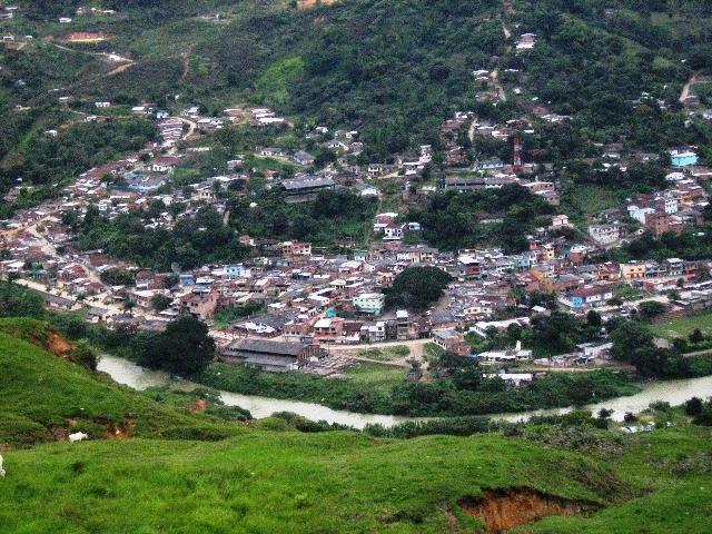
Suárez as such, is a dream territory that has its origins dating back to 1880, when, due to the desire for a better social welfare of some families crowded together in the so-called “Valle del Cauca”, they decided to venture out to seek new paths of life, taking as conception that the banks of rivers such as the Cauca are sources of gold wealth in the sense that the waters have material channels of all kinds, among them, the precious mint; and at the agricultural level, taking into account that they are fertile lands since all the nutrients in the soil are cemented in areas near the rivers by actions of the same nature; on the other hand, the impulse that led adventurous families to reach the area was to observe and analyze the climatic reactions, since since ancient times it is believed that in winter, in sectors where strong storms are generated "there is gold." The families that arrive form a small village called Aganche, in honor of some English gold seekers who were in the area. Already around 1,900, the interest on the part of the government to intercommunicate the Valley with Cauca through the railway arose, around 1,919, the then president Marco Fidel Suárez decided to advance the railway project through the sector called Aganche, in 1,920 He visits the place and decides to create a railway station and the assembly of a unique turntable in the area for the railway, thus attracting more immigrants from different areas, merchants, barequeros, farmers and fishermen in search of fortune. And it is in this way that the name of Suárez to the existing hamlet is born in Homage to Marco Fidel Suárez, then the population expands and a man named Juan emerges who consolidates himself as a leader in his community, which had the physiological characteristic of being "Blanco", then a neighborhood called "Juan Blanco" was created, the first neighborhood of the village. With the expansion and impact of a railroad, the market was formed around the market place created and that is how the Suárez village, which belonged to the Municipality of Buenos Aires, is erected as the head of the town with the name of “Corregimiento de Suárez ”, with families such as Monsalve, Martínez, Rincón, Ospina, Cabrera, among others being the promoters of this development. In the year 1935 during the presidency of Alfonso López Pumarejo, a contract was signed with the company Asnazu Gold Dredging Limited, for the technical exploitation of gold on the beds of the Ovejas and Cauca rivers, located mainly in the mines of Portugal, Paso Bobo, Santa Bárbara, La Caucana, Piedra Sentada and La Cabaña, thus generating a great source of employment for a high margin of the population. In this way the town of Suárez was the first generator of fiscal resources for the municipality of Buenos Aires, as it is a region rich in minerals, such as gold, coal, bauxite and the development of a very rich agricultural production, coming to be considered as Pantry for the supply of terminal markets in Cali and Popayán itself. At the end of the 70s the construction of the Hidroeléctrica de la Salvajina began, whose general purpose was focused on the regulation of the Cauca River through the control of floods that occurred downstream, especially in the Department of Valle del Cauca and as additional purpose the production of electric power with a capacity of 270 megawatts. Around 1980 - 1983, the railroad rails began to be raised, making communication difficult and a serious backwardness began to be generated in these populations, which ended up changing their way of life, due to the scarcity of sources of income. Once the railroad is lifted, importance is given to the highway in view of the situation of the construction of the hydroelectric plant, which will nevertheless influence eleven municipalities, the main ones being Suárez and Morales respectively, in this way the economy factor is again encouraged with job options. The construction of the work collaterally brings socio-cultural changes towards 1985, especially for all those who derived their economy from river mining, it was also the determining factor so that in 1989, by Ordinance of the Departmental Assembly of Cauca, it was determined as a municipality since There was significant income represented in royalties in accordance with Law 86 of 1,981, resources with which public service works, infrastructure and urban equipment were built. The idea of converting the Suárez sector into a Municipality arose in the 70s and 75s, a period in which a council for the Suárez municipality was appointed, at the same time the Hospital, a marking plaza, a public slaughterhouse and other works of interest were organized in these factors greatly influenced the CVC. For the organization as a municipality, various variables and interests prevailed, such as: Political aspects: providing autonomy, leadership, recognition at the local, regional and national levels. Economic interests: Take advantage of own resources for the development of a single locality (Suárez), with which other resources would be channeled and problems would be addressed more effectively. Social benefits. By having autonomy in investment, one could better work around basic needs such as health, education, housing, among others. Under these conditions and after struggles, the new municipality was created by ordinance 013 of December 1, 1989, it has counted from the date on a sustainable development and some alternatives for progress that project it as one of the entities with promising future in the north of the department of Cauca.
Physical description:
It limits to the north and east with the municipality of Buenos Aires, to the southeast and south with the Municipality of Morales and to the west with López de Micay, with an area of 389.87 km2, of which 3.57 km2 corresponds to the urban. With a height above sea level of 1,050 m, average temperature 27ºC. It is distant from the capital of the department, Popayán 107 km. It has important rivers such as the Cauca, Ovejas, Marilopito, Damián, Inguitó, Asnazú and Marilópez, with the El Chupadero, La Chorrera, Los Pasos, Los Morados, La Laja, El Danube and Saint Michael. An Artificial Reservoir in the SALVAJINA Hydroelectric Plant, called Ciro Molina Garcés Dam. In its orography the heights of Sardinas, Altamira, San Pablo, Las Tijeras, Delucha, Las Auroras and los Micos, Hills such as Damián, El Jigual, Birimbi, La angarilla, El Alcalde, and Piedra Escrita, Lomas such as Canoa, Redonda stand out. , El Mangón, Palma Russia, Peñas blanca, Bellavista, Comedulce, Salvajina, La Toma, Cabuyal, La Estrella, La Alejandría, Los Motilones, Las Canoas, Loma de San Pablo, La Sierra, El Paso, El Pijol, Lomalta and Pechuga , The Germany. With heights ranging from 1000 m.a.s.l. up to 2500 m.s.n.m. Politically it is divided into the townships of Mindalá, La Toma, Asnazú, Betulia, Agua Clara, Robles and La Meseta.
Limits of the municipality:
It limits to the north and east with the municipality of Buenos Aires, to the southeast and south with the Municipality of Morales and to the west with López de Micay, with an area of 389.87 km2, of which 3.57 km2 corresponds to the urban.
Total extension: 389.87 Km2
Urban area extension: 3.57 Km2
Rural area extension: 386.30 Km2
Altitude of the municipal seat (meters above sea level): 1023
Average temperature: 27 ºCº C
Reference distance: 107 Km from Popayán
Ecology
It has important rivers such as the Cauca, Ovejas, Marilopito, Damián, Inguitó, Asnazú, Marilópez and San Miguel, with the El Chupadero, La Chorrera, Los Pasos, Los Morados, La Laja, and El Danubio streams. An Artificial Reservoir at the SALVAJINA Hydroelectric Plant, called Ciro Molina Garcés.
Economy
Based primarily on the primary sector; agriculture (coffee, cassava, sugar cane, corn, beans, fruit trees, among others) and mining mainly. Gold extraction is carried out in the southeastern area of the municipality in the vicinity of the townships of La Toma and Mindalá, this being the main source of exploitation. In the northwestern area, agricultural production is the most important economic activity, to such an extent that agriculture participates in 52% of the municipality's production, followed by mining activity with 27%, trade with 3% and 18 The remaining% is in activities such as fish farming, poultry farming, livestock, among others. In some sectors, forestry is practiced by Smurfit Cartón de Colombia. Tourism does not yet present an important economic activity for the Municipality due to its deficient infrastructure and publicity, but this sector promises to become a leading activity if the natural and artificial scenic advantages that this municipality has are taken advantage of, especially that represented by the lake or Salvajina reservoir and the Municipal Water System including its main rivers.
Communication channels
Aerial:
Terrestrial:
In the municipality of Suárez, the road infrastructure shows a dominant terrestrial communications system, of the order of 163 km of roads, whose distribution by townships reveals the lack of accessibility that those that face the south of the municipality have, such as La Plateau and Clear Water; and a fluvial system that has occurred as a response to the previous problem, in the part of the reservoir; the first made up of a main unpaved road, which communicates the municipality, both with the department of Valle del Cauca and with the municipality of Morales; other secondary roads, communicate the municipal head with the heads of corregimientos; part of this system is also made up of the small roads that interconnect the different paths.
Main festivities
Adoration of the child God
This celebration takes place on December 24 in the Belén neighborhood.
August 30, festivities of Santa Rosa de Lima
This image was brought in the time of slavery by the slaves, to the Gelima village. With the abolition of slavery, those who were free dispersed and 20 of them formed the village of La Toma, taking with them the image of Santa Rosa de Lima, thus beginning this celebration that has lasted to date. It is carried out with the presence of the priest to celebrate a holy mass that later culminates with a procession. It should be noted that this date is used to celebrate baptisms, first communions and marriages. In this celebration, food and liquors are prepared and sold; the people sing and dance to the sound of wind music, hired and paid for by the organizing committee. Fireworks are held, castle burning, contests, where the community is the one that participates.
December 16 to 25, December commemorations
The Novena of the Child God is an ancestral custom of this community. Each village is used to worshiping the image of the Child God, dancing and singing around a manger that is made in a family home. Christmas carols are sung, praised whirlwinds to the sound of the shawm.
Agricultural and tourism fairs
At the municipal seat we celebrate traditional fairs during the month of October.
July 16, festivities of the Virgin of Carmen
This festivity is celebrated especially in the villages of Gelima and Yolombó; in it the people through the organizing boards called pro-parties "DE LA VIRGEN DEL CARMEN" take the priest from the municipal seat with all expenses paid to celebrate the holy mass. Different foods are prepared to sell; there is a booth where people dance and have a drink until the next day. It should be noted that this party is attended by people who still live in the community and those who have migrated to other cities.
Hanging duck
It consists of placing two fixed guaduas on the ground, at a distance of more or less than 8 meters, in the same direction. Then a manila is tied, leaving a fixed knot on one side and a sliding knot on the other side that allows the manila to rise and fall. In the center of the manila a duck is tied by the legs. The contest is carried out on horseback; Whoever downloads it will be the winner and is committed to contributing the duck for next year.
Easter
As is customary in Colombia, in our municipal seat we celebrate Holy Week annually.
tourism
The Salvajina dam is our main tourist attraction. Second, our hydrography is so diverse that we find diverse landscapes around the Cauca, Inguitó, Asnazú, Ovejas rivers, the San Miguel stream, the La Chorrera stream and its slopes. Likewise, we possess a variety of cultural resources (gold, cultural exhibitions, gastronomy, crafts), which gives our lands a more diverse cultural geography. We also have hills as diverse in their physical geography as El Cerro Damián, El Cerro Tijeras, Cerro Negro and Comedulce, on the western mountain range. We invite you to visit the Lake La Salvajina Dam, La Chorrera, El Salto, Charco Azul, the Río Ovejas, El Sapo, and La Bocatoma, places with unique landscapes in the Pacific.
Comments
We don´t have yet any comments about:
Suarez
Suarez
Be the first to leave a comment as it is very important to inform other people
Outros locais a visitar
Within a radius of 20 km from:Suarez
Unfortunately we do not have information on other places to visit in this area yet
Hotel reservation near Suarez within a radius of 20 km
No results
Why to book with ROTAS TURISTICAS
The best prices
Our partnerships with the world´s largest operators offer research on the best market prices.
More options
At Rotas Turisticos you can book the hotel, buy the air ticket, book the transfer from the airport to the hotel and vice versa, book the local excursions, rent the car, take travel insurance and consult the places to visit and where to go.
Holiday Tips & Destinations
Hundreds of holiday destinations with all the options that allow you to easily choose the destination that best suits your dream vacation.
ROTAS TURISTICAS
Links
Follow us on social networks


